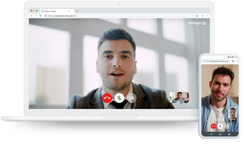
Psicoterapia Online por videollamada
Se evaluará esta posibilidad a partir de las circunstancias y características del caso.
Sin Esperas
Coordina con tu terapeuta y coordina a la hora adecuada.
24×7
Vos y tu terapeuta eligen días y horarios sin restricciones.
Estés dónde estés
En tu casa, en el trabajo o en donde quieras, tu lugar es decisión tuya.
Los 365 días del año
Vacaciones, feriados, días festivos. El día que vos arregles con tu terapeuta.
Accedé a tu sala de consulta
Si tenés una sesión agendada con nuestros profesionales, hacé click aquí y buscá su sala online
Nuevos números de Atención General y Consultas de Primera Vez (solo por Whatsapp, horario activo de 10 a 17hs).
Hablá con nuestro centro de atención al afiliado
y obtené rapidamente la respuesta que buscás

Protocolo Sanitario para Consultas Médicas Programadas
Protocolo Sanitario para Consultas Médicas Programadas

Red de Atención
en salud mental
Atención ambulatoria
Mediante la atención telefónica, a través de un chat on line o en forma presencial. Psique ofrece …
Se accede al servicio con una primera entrevista de orientación que lo ayudará a definir cuál es …
El avance continuo de los descubrimientos médicos ofrece un amplio abanico de psicofármacos cada vez con …
A los talleres temáticos concurre un nutrido grupo de personas que quiere profundizar sobre …
Atención de segundo nivel
El HDD es un recurso intermedio entre la internación y el alta. El paciente concurre a una instalación a …
Cuando se puede evitar una internación se organiza un tratamiento domiciliario y ambulatorio con …
De acuerdo al grado de compromiso de la vida cotidiana, de los vínculos sociales, familiares y …
Atención aguda
En las situaciones donde se pierde el control de los impulsos, el curso del pensamiento, o está en …
Área Académica
900 Profesionales a lo largo del todo el país
Atención ambulatoria
Atención de segundo nivel
Atención aguda
Sumate a nuestra red profesional
Dejanos tu CV
Formá parte del equipo de Psiqué
Se requiere foto personal, fecha de finalización de los títulos y los cursos, junto con la dirección y fotos de los consultorios.
Instituciones Tipos de prestaciónZonas
Búsquedas Activas
1. Especialista en salud mental de personas mayores.
(Lorem ipsum dolor sit amet, consectetur adipiscing elit)
2. Licenciado en Psicología educacional.
(Lorem ipsum dolor sit amet, consectetur adipiscing elit)
3. Especialista en Psicología laboral y organizacional.
(Lorem ipsum dolor sit amet, consectetur adipiscing elit)
¿Necesitás una consulta y tenés alguna de estas prepagas?


Primera vez, Atención general, Continuidad y Urgencias
Urgencias
0810-222-7747
De 10 a 17hs llame a Psiqué, fuera de este horario contáctese con los siguientes números de acuerdo a su cobertura
0810-444-72583
0800-888-66468
0810-222-7747 / (11) 4986-4403
0810-777-74727 / 4860-7100
4323-0423 / 0443
URGENCIAS GUARDIAS PÚBLICAS
Hospital Interdisciplinario Psicoasistencial José Tiburcio Borda
(011) 4301-3655
Hospital Neuropsiquiátrico Braulio A. Moyano
(011) 4301-3655
SAME
107
Hospital Infanto Juvenil Dra. Carolina Tobar García
(011) 4305-6108
Tu sistema de salud en Psiqué
Si tu prepaga no cubre tu terapia, te explicamos como pedirla.
Red de contacto
0810-222-7747
¿Tenés alguna consulta o sugerencia?
¡Escribinos, nos pondremos en contacto a la brevedad!
Psiqué S.A. © 2021. Todos los derechos reservados. Vea nuestros términos y condiciones para mas información.